Drone positioning system with geo-fencing
Task and input
“We plan to build a geo-fenced area and track a custom drone within it. Since we need accurate tracking, we are interested in acquiring a positioning system. However, I have some doubts regarding the scenario.
In this case, our geo-fenced area is a mix between indoor and outdoor (see attached image) of 100m2. Note that the roof is covered by a metal structure. Also, our drone has about 1 kg payload.
I am not sure what would be the best solution for this purpose:
- Starter Set Super-MP-3D
- Starter Set NIA-SmallDrone
- Starter Set Industrial-NIA-01
Considering the requirements of the area (it is not completely indoor and the stationary beacons would be installed on the corners of the roof, which are not covered) and the drone (~1kg payload).”
Overall view of the area
Drone flying area - top view
Dimensions share the by the customer and the requested placement of the beacons based on the initial email discussions:

Drone flying area - side view

Recommended solution
Basically, after initial email discussion, the prospecting customer already had a good idea of where the stationary beacons shall be placed, how many of them and where they shall be facing. However, small corrections should have been applied anyway:
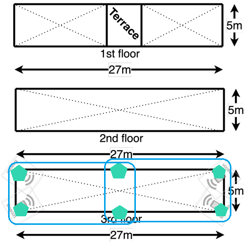

4 x stationary beacon is not enough => 6 x stationary beacons
- Calculate very carefully for the maximum distance that beacons need to cover. For example, for the red dot, it would be sqrt(27^2+17^2+5^2) = 33.3 meters, which is a lot. Yes, our system is capable of tracking 30 meters even more, but don’t overstretch it. Besides, with the higher distance, chances that the system will reject the measurement because of too low signal or too noisy signal, etc., increase, and you will have more and more spotty tracking, which will create a more difficult life for your drone’s autopilot. Don’t over-stretch, particularly for the drones, because the cost of errors with drones is higher than with forklifts or robots. Drones just fall
- The larger the size of the submap, the lower the update rate will be. Particularly for drones, the update rate is important. Thus, very often, it is better to install more stationary beacons, have smaller submaps, and enjoy a higher update rate, more solid tracking, and, as a result, more predictable autonomous flight
Look at the narrow shape of the area
Another reason why, at least, 6 x stationary beacons must be used is the geometry of the area – it is narrow – just 5 meters width and 27 meters length. If 3D (XYZ) view is taken, it is even narrower.
We described the geometrical implications of too-narrow or too-wide bases in the past. This case is a typical example of both too narrow and too wide simultaneously because it is a 3D case.
Thus, all measures shall be taken to make it less extreme. And the easiest way is to add a pair of beacons in the middle. Submaps will be shorter and less elongated, and triangles will be less acute.
It doesn’t look worth increasing the complexity further by adding a lower layer of beacons, etc. Yes, the distances will be even shorter, but there will be too many submaps, complexity increases, and the number of handover zones increases, but the gain is not so significant anymore.
Configuration
Proposed configuration:
- 6 x Super-Beacons with Magnetic Holder, Full-Size Antenna, Converter-220V-USB
- 2 x Super-Beacons for Location + Direction
- 1 x Modem v5.1 with Full-Size Antenna
Why not Mini-TX as a mobile beacon?
Mini-TX is a great mobile beacon for small drones. Its small size is the beacon’s only advantage as compared to Super-Beacon, for example. However, the planned drone has up to 1 kg payload capacity, i.e., 10-20 grams for the beacon doesn’t make much difference. However, the smaller and weaker transducers and smaller ceramic antenna – all these are clearly pointing towards the Super-Beacons.
Why not Industrial Super-Beacons as beacons?
Industrial Super-Beacons, or Industrial beacons in general, are notably larger, heavier, don’t have internal batteries, and generally speaking, are designed for other applications – not for drones. Their clear advantages – wider working temperatures, rigidness of the housing, much higher ingress protection, and additional interfaces, including RS485, do not play valuable roles in this case. However, larger sizes and weights are playing against using them in the system.
Geo-fencing zone
Setting up a geo-fencing zone is pretty straightforward.
In fact, it is even simpler clicking on the map in the modem view using Shift+Click. Note the modem view – not the submap view. Otherwise, you will create a service zone for the submap – not the geo-fencing zone.
The geo-fencing zone settings can be set in the dashboard. The geo-fencing zone violation can be read in the live data stream or in the CSV file.
Summary
This is a typical request for the drones. In fact, it is a relatively simple one because the area is just one open space – not multiple small rooms. The key points to remember:
- Line of sight
- Maximum distances
- Trade-off between the cost of beacons, update rate, accuracy
The only minor peculiarity of the case is a request for the geo-fencing zone for the drone. But that is a business as usual.
| M | T | W | T | F | S | S |
|---|---|---|---|---|---|---|
| 1 | 2 | 3 | 4 | 5 | 6 | 7 |
| 8 | 9 | 10 | 11 | 12 | 13 | 14 |
| 15 | 16 | 17 | 18 | 19 | 20 | 21 |
| 22 | 23 | 24 | 25 | 26 | 27 | 28 |
| 29 | 30 | 31 | ||||